Last year, we shared how the WeTHRIVE!℠ communities of Lincoln Heights and Mt. Healthy created Active Transportation Plans (ATP) to make their streets safer for pedestrians, cyclists, and anyone not riding in an automobile.
After presenting ATPs to their respective village/city council, the WeTHRIVE! teams worked with village/city administration to plan active transportation demonstration projects. Read on to find out how these WeTHRIVE! communities are bringing active transportation to life in their neighborhoods!
What is active transportation?
Simply put, active transportation refers to traveling without using a car. It’s often described as walking, biking, and rolling – with rolling referring to wheelchairs, strollers, scooters, skateboards, rollerblades, etc. For an in-depth look at active transportation and the planning process in two WeTHRIVE! communities, see Active transportation: A roadmap to safer, healthier, more connected communities.
What are active transportation demonstration projects?
Demonstration projects are temporary, quick, low-cost ways to show communities what they can do to promote active transportation. They give residents an idea of what things like safer crosswalks and traffic calming could look like in their neighborhood.
An active transportation demonstration project often engages residents by encouraging them to get involved in planning and executing ideas, as well as providing feedback on how it’s working.
For Lincoln Heights and Mt. Healthy, the demonstration projects show how small improvements – like new paint or planters – can make a big difference.
Compton & Perry in Mt. Healthy
The WeTHRIVE! Mt. Healthy team and the city of Mt. Healthy chose the intersection of Compton Road and Perry Street for their first active transportation demonstration project. This busy corner – home to a daycare and three churches – is identified in the Mt. Healthy Active Transportation Plan as a priority project for crossing enhancements.
Jacqueline Johnson-Wilkinson is Mt. Healthy’s WeTHRIVE! neighborhood navigator. She was involved in the active transportation planning process from the beginning, attending meetings, engaging the community, and participating in the walking audit.

Jacqueline says there used to be a traffic light at Compton and Perry, but now there are only stop signs for cars traveling on Perry Street. “It could get really congested and I’ve seen several accidents and many near miss accidents at this intersection.”
Crash data backs this up: between 2022 and 2024, it was the fourth-highest crash location in the city. If you exclude Hamilton Avenue, which is a state road, this intersection is number one for crashes.
For the first phase of this project, city public works employees repainted the existing crosswalks, painted new curb extensions, and installed planters within the extensions. “We had observed similar traffic calming measures in North College Hill,” Jacqueline explains. “Painting the crosswalks gives them more visibility. The plant stands add some beautification to that area, as well as bringing awareness to the crosswalk and alerting drivers to slow down and to take notice.”


The second phase of the project will involve community members painting designs inside the crosswalks. This was scheduled for earlier in the summer but had to be postponed due to weather.
Jacqueline says community members appreciate the crosswalk enhancements and some have commented that they seem to be slowing traffic down a bit. They are especially grateful for the beautification provided by the new planters.

The Forest Avenue Wetlands Project, the city of Mt. Healthy, and the Mt. Healthy Historical Society developed a Walker’s Guide to Mt. Healthy. Aaron Horsley and Alex Kascak (who are also members of the Mt. Healthy WeTHRIVE! team) created this printed guide that highlights safe routes within the community for biking and walking. Detailed maps guide you to locations of note throughout the city. The document also includes QR codes that can be scanned to access digital maps.
Safer crosswalks in Lincoln Heights
The Lincoln Heights WeTHRIVE! team and the village administration chose several areas to implement active transportation demonstration projects. These include locations identified in their Active Transportation Plan as areas that could benefit from enhancements.
Mangham & Steffen in Lincoln Heights
The first demonstration project to be completed in Lincoln Heights was the crosswalk at Mangham Drive and Steffen Avenue, which is close to the Lincoln Heights Health Center, an important spot for the village and surrounding communities.

“The health center gets a lot of foot traffic from people walking up from the bus stop and crossing the street, so we thought that would be a good spot to do our first project,” says Chris Williams, who is Lincoln Heights’ WeTHRIVE! neighborhood navigator and director of public works with the village. Chris was involved in the active transportation planning process from the beginning.
As you can see in the picture below, the crosswalk was enhanced with paint and stencils – notice the detail of the stencils, which is appropriate because the intersection is so close to the health center!

Magee & Steffen in Lincoln Heights
Another busy crosswalk is at the intersection of Magee and Steffen Avenues. Chris and his team painted the crosswalk, adding some nice touches with the hand prints of community members. They also created a curb extension with flower planters, pylons, and flexible curbing.


The curb extension marks the 30-foot no-parking zone from a stop sign. When cars are parked too close to a stop sign, this can block the view and make it dangerous for people walking, biking, or driving.
Chris says residents especially appreciate the planters, which beautify the area while drawing attention to pedestrians and the crosswalk. “And it absolutely slows down traffic,” he adds.
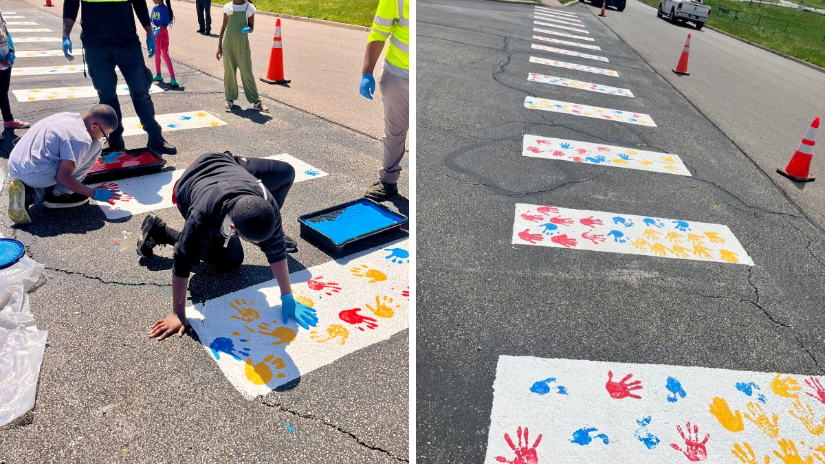
Crosswalk at Lincoln Heights Elementary School
For their third demonstration project, the WeTHRIVE! team partnered with Dawn Bailey, principal of Lincoln Heights Elementary School. “The playground entrance behind the school on Leggett Street had a crosswalk at one point, but it was covered up when the school parking lot was blacktopped,” Chris explains.

Like the other projects, this one served as an opportunity to get community members involved. Once the new crosswalk was painted, Lincoln Heights Elementary students added their hand prints in colorful paint.
“The community engagement piece for this project was really successful,” Chris notes. “It was not only an enhancement for the community, but it involved the children who will use the crosswalk.”
Advice for other communities
Jacqueline encourages other communities to get involved with active transportation. She appreciates how the process has engaged her community every step of the way. “I think it’s definitely something that a community should prioritize – creating an active transportation plan and then creating activities and engagement around that plan.”
Chris says that while the projects may seem to be ways to beautify the area, they really do make the intersections safer. He admits that he had his doubts at first, but he sees traffic slowing down. And he’s seen the impact of getting the community involved in these projects.
What’s next?
Key next steps include continuing to implement the Active Transportation Plans for Mt. Healthy and Lincoln Heights and identifying funding to support projects recommended in the plans.
The communities will also compile feedback about the active transportation demonstration projects to use moving forward.